The Ogre Road

From Guild Wars 2 Wiki
Jump to navigationJump to search

The Ogre Road

1Complete heart (map icon).png 1Waypoint (map icon).png

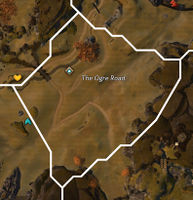
The Ogre Road map.jpg
Map of The Ogre Road

Stronghold of EbonhawkeThe Siege PlainsLast Stand ShelterBlackwing ExcavationHautclaire ValeThe Ogre RoadHunter's GorgeGrimm HillsVulture's SweepWarrior's CrownSniper's WoodsBelag CrossroadsAxedrag CutFlameroot CavernsHighden CavesMithric CliffsWildlin NarrowsGillfarn PlainsHalkor MeadowsThunderbreak HillsTenaebron LakeVarim's RunSecluded GlenDragonrot DomainsBento CanyonTanglerot HillsThe Ogre Road locator.svg
Level
34
Type
Area
Zone
Fields of Ruin
(Ascalon)
Connects to
Mithric Cliffs (NE)
Hunter's Gorge (NW)
Wildlin Narrows (SE)
Hautclaire Vale (SW)
Image(s)

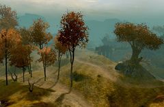
The Ogre Road.jpg

Click to enlarge.

The Ogre Road is an area in the southeast of the Fields of Ruin. It is named after the trail traversing ogre territory.

Locations and objectives[edit]

Renown Hearts
Complete heart (map icon).png Harass the ogres of Foulbear Kraal (33)
Waypoints
Waypoint (map icon).png Ogre Road Waypoint —

NPCs[edit]

Allies[edit]

Norn

Services[edit]

Renown Heart (map icon).png Vanguard Scout Pickins (33)

Pets[edit]

Foes[edit]

Ambient creatures
Bears
Canines
Devourers
Griffons
Ogres
Porcines

Crafting resources[edit]

Resource nodes
Mine resource (map icon).png Iron Ore
Wood resource (map icon).png Gummo Sapling
Plant resource (map icon).png Portobello Mushrooms
Plant resource (map icon).png Root Vegetables