Template:Location infobox
From Guild Wars 2 Wiki
Jump to navigationJump to search
Location infobox
- Type
- Unknown
Description[edit]
This infobox should be used for regions, zones, areas, points of interest, etc., i.e. all locations mentioned here. See also parameter type below.
Usage[edit]
{{Location infobox
| name =
| hearts =
| waypoints =
| points-of-interest =
| hero challenges =
| vistas =
| map =
| map text =
| levels =
| type =
| within =
| connections =
| pets =
| loading-screen =
| gallery1 =
| gallery1-text =
| id =
| sector id =
| requires =
}}
Parameters[edit]
All parameters are optional.
- name
- Location name. Defaults to
{{PAGENAME}} - hearts
- Number of renown hearts
- waypoints
- Number of waypoints
- points-of-interest
- Number of points of interest
- hero challenges
- Number of hero challenges
- vistas
- Number of vistas
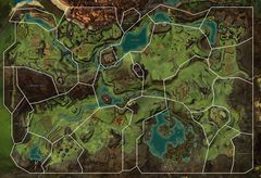
- map
- Map image (do not include the "File:" prefix). Defaults to '
{{PAGENAME}} map.jpg' - map text
- Optional. Defaults to "Map of {{{name|{{PAGENAME}}}}}". As an example, this could be used on zone articles with multiple layers to label that the particular area is on the Depths level.
- levels
- Depends on the type used, see as follows
- Zone: The level range for the zone. Separate minimum and maximum levels with a single hyphen "-", e.g.
60 - 70 - Area: The effective level of the area. For the case of dungeon areas where there is an explorable level and a story level, separate values with commas.
- type
- The type of location. Use plain text with no wiki-links.
- Available options: "Continent", "Region", "Zone", "Area", "City", "Guild hall", "Dungeon", "Activity", "Strike Mission", "Raid", "Fractal", "Point of interest", "Landmark", "Jumping puzzle", "Mini-dungeon", "Guild puzzle", or "Instance".
- within
- The parent location of the location being described. Use plain text with no wiki-links. For zones, this should be a region; for areas, this should be a zone; for everything else, this will usually be an area. If within is an area or zone, the parent of within will be displayed underneath in small text.
- connections
- Other locations that this one has connections to. Usually only specified on zones. Separate multiple connections with
<br>and add your own wiki-links. The cardinal direction is usually specified in brackets after the zone name; (N), (S), (E), (W), (NE), etc. In the case of a portal, add(portal)instead of direction. See the Queensdale example below. - pets
- Ranger-tameable juvenile animals. Like "connections" above, separate with
<br>and provide links manually. Include for zone infoboxes, redundant for location infoboxes (see discussion page). - objectives
- Defaults to "n". Only set equal to "y" if the location has map objectives that contribute towards world completion (core tyria).
- loading-screen
- Loading screen image (do not include the "File:" prefix). Defaults to '
{{PAGENAME}} loading screen.jpg' - gallery1 ... gallery5
- Optional. Images related to the location. The first image defaults to
{{PAGENAME}}.jpg. - gallery1-text ... gallery5-text
- Optional. Image descriptions.
- locator
- Use to specify the SVG locator image if the page name doesn't match the filename. Defaults to '
{{PAGENAME}} locator.svg' - locator text
- Optional. Very seldom used, but allows the default of
"Location within {{{within}}}"text to be over-ridden with"Location within {{{locator text}}}". - locator template
- Optional. Very seldom used, but allows to specify a different template for the locators than the one used by default (
"Locators/{{{within|}}}"). - coordinates
- Optional. The X and Y coordinates for the location. Displays an interactive map with a marker at the given location. e.g.
[12345, 31321]. Only displayed for pages with the "type" set equal to "Point of interest", "Dungeon" or "Landmark". See Template:Infobox map for details on how to capture coordinates. - localtiles
- Optional. If set, uses local wiki tiles instead of the API raster tiles. See Category:Map raster tiles.
- id
- The game ID for the location, displayed as a game link. Shown directly as a chat link for points of interest. Also provides an API link to API:2/maps if appropriate. Also sets a variable "#var:mapID" which allows Template:Interactive map to work. Sets the semantic property Property:Has region id or Property:Has map id if appropriate.
- sector id
- Only to be set on area pages. The game ID for the sector (intentionally separate from the
idparameter above), not visually displayed in the infobox however this parameter sets the semantic property Property:Has sector id. This property is found in the continents API endpoint. Separate multiple values with a semi-colon (;) - this is required functionality for areas which have been documented for both story and explorable dungeons. - continent id
- region id
- map id
- The above three parameters are only to be set on pages which contain sectors. They also correspond with the values from the continents API endpoint.
- categorize
- "y" or "n" to turn on/off categorization. Default is on for main namespace articles and off for others. If using "status", don't set this parameter.
- status
- Status of content. Only set if not currently obtainable ingame, displays relevant notice. Available options: "historical", "future", "unimplemented", "current" (default). See {{infobox status}} for options.
- status notes
- Additional notes to explain the given status. For example, if the content was only available during a specific release.
- status date
- Optional. Sets the date of the update that marked this skill as historical (in YYYY-MM-DD format).
- requires
- The expansion or living world season required to access the content. Displays a notice of the release. See {{infobox requires}} for options.
Examples[edit]
{{Location infobox
| name = Queensdale
| map = Queensdale map.jpg
| type = Zone
| within = Kryta
| hearts = 17
| waypoints = 16
| points-of-interest = 21
| hero challenges = 7
| vistas = 3
| levels = 1-17
| connections = [[Divinity's Reach]] (N)<br>[[Gendarran Fields]] (E)<br>[[Kessex Hills]] (S)
| pets = [[Krytan Drakehound]]<br>[[Forest Spider]]<br>[[Pig]]<br>[[River Drake]]
| loading-screen = Queensdale loading screen.jpg
}}

{{Location infobox
| name = Salma District
| map = Salma District Map POI.jpg
| type = Instance
| within = Divinity's Reach
| points-of-interest = 5
| loading-screen = Salma District loading screen.jpg
}}

{{Location infobox
| name = Barradin's Vaults
| type = Point of interest
| within = Charr's Triumph
| id = 1458
}}
Queensdale
17 16 21 7 3
- Levels
- 1 – 17
- Type
- Zone
- Region
- Kryta
- Connects to
- Divinity's Reach (N)
Gendarran Fields (E)
Kessex Hills (S) - Pets
- Krytan Drakehound
Forest Spider
Pig
River Drake


