File:Mistonium Cache Farm Route.jpg

Original file (2,406 × 1,829 pixels, file size: 1.11 MB, MIME type: image/jpeg)
Summary[edit]
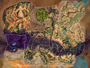
A Map based on Mervil's map showing spawn locations of Mistonium nodes but with all the Mist-touched cache locations indicated with green dots.
This is a possible farm route starting from Sun's Refuge (Yellow Star) and ending in the ??? region (Orange star). It passes by all the Mistonium nodes potential spawn points while collecting all the Mist-Touched caches.
The yellow dashed lines are Jackal sand portals and the green dashed lines are terrain passages going inside the mountain.
Note that in game the Mistonium nodes will appear on your map if they are spawned as you get near them so you do not have to go all the way to the point if you don't see it appear.
Licensing[edit]
| This screenshot contains property of ArenaNet or NCSoft which is used with permission. The terms of the permission do not include third party use. It is not released under the GFDL. Please see Guild Wars 2 Wiki:Copyrights for further information. |
File history
Click on a date/time to view the file as it appeared at that time.
| Date/Time | Thumbnail | Dimensions | User | Comment | |
|---|---|---|---|---|---|
| current | 22:54, 9 September 2023 | | 2,406 × 1,829 (1.11 MB) | J.A.R.V.I.S. (talk | contribs) | Re-uploaded as same quality, but reduced file size, for better user experience |
| 19:44, 7 December 2019 |  | 4,812 × 3,658 (6.79 MB) | Fëana (talk | contribs) | A Map based on Mervil's map showing spawn locations of Mistonium nodes but with all the Mist-touched cache locations indicated with green dots. This is a possible farm route starting from Sun's Refuge (Yellow Star) and ending in the ??? region (Orange... |
You cannot overwrite this file.
File usage
The following page uses this file: