File talk:Tyria map (novel).jpg
I will now laugh at the sunken Ring of Fire. Eive![]() 04:52, 16 July 2010 (UTC)
04:52, 16 July 2010 (UTC)
- Looks like Vigil Keep could almost be built on the site of Beacon's Perch. I'm surprised Hoelbrak is so close to the Wall, too. Arshay Duskbrow 05:05, 16 July 2010 (UTC)
- Vigil Keep is too close to Kryta to be Beacon's Perch. It seems off of the map, to the right of Deldrimor Bowl. Closest to anything known on the GW1 map would be Graggult's Keep. And the Ring of Fire isn't sunk. -- Konig/talk 05:07, 16 July 2010 (UTC)
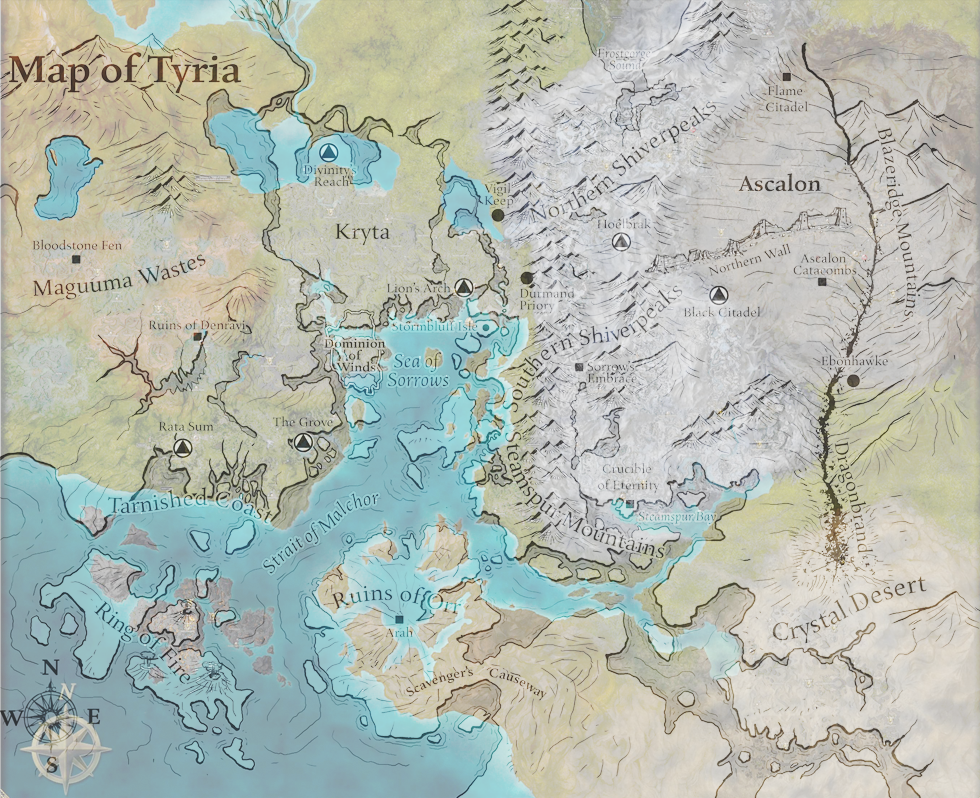
- (Edit conflict) The Black Citadel appears to be in the same place as Sardelac Sanitarium, the Flame Citadel is right around Doomlore Shrine, "Dominion of Winds" appears to cover the area from Sanctum Cay to Talmark Wilderness. Divinity's Reach was previously Divinity Coast. Ruins of Denravi looks north of the actual Henge of Denravi, Crucible of Eternity was Droks. I can't tell if either Vigil's Keep or Durmand Priory is at the location of Beacon's Perch, although my money goes on Vigil's Keep. Bloodstone Fen remained in the same place, as did Rata Sum, the Grove (not sure how it survived the entire surrounding area being flooded though) and obviously the Ruins of Ascalon and Lion's Arch. Hoelbrak looks like it is on top of the Central Transfer Chamber, or perhaps Yak's Bend. Ebonhawke for some reason decided to park right next to the minions of Kralkatorrik, and the Stormbluff Isle is just the islands south of Lion's Arch, and Sorrow's Embrace is now the former Stone Summit controlled Dredge capital. And that is my opinion of everything but Arah, feel free to not take this seriously. Eive
 05:18, 16 July 2010 (UTC)
- @ Konig, the RoF islands have changed significantly. Some parts have sunken while other have come up from the depths. (Or been formed from cooled lava) Eive 05:21, 16 July 2010 (UTC)
- Here are some overlays. Don't take them completely at heart, but it does give the general area of everything when compared to a GW map. I think the first link is broken though, not sure because my comp is being tweaky.--Corsair
@Yarrr 05:32, 16 July 2010 (UTC)- @Eive: Yes, but they are not sunk. Just reshaped. Oh, and Eive, the map we have is only a little bigger than the Prophecies map. It doesn't go up to where Doomlore Shrine is. And Durmand Priory is at where I thought: The gw1:Temple of Grenth. Hoelbrak is closer to the bottom of Traveler's Vale. -- Konig/talk 05:40, 16 July 2010 (UTC)
- "The Black Citadel appears to be in the same place as Sardelac Sanitarium". It was actually confirmed to be built upon the ruins of Rin.
- "Divinity's Reach was previously Divinity Coast". IIRC, it'a new city somewhere inside (or near) the Divinity Coast explorable area but it was confirmed not to be in the exact same place as the GW1 outpost. Chriskang 08:08, 16 July 2010 (UTC)
- "It was actually confirmed to be built upon the ruins of Rin" *Checks Black Citadel page* Didn't know that... Well as people managed to notice, my mostly in-mind scaling was a bit wrong, some of us didn't have overlain maps. :P And @ Konig, we call that a joke. It was partially sarcasm, as it is the "Ring of Fire." Eive 09:19, 16 July 2010 (UTC)
- The joke must be lost on me since there is a Ring of Fire underwater in the pacific ocean.-- Konig/talk 20:55, 16 July 2010 (UTC)
- I don't get it, either. I'm slightly disappointed at the random islands popping up and land mass being added in places after a flood. Then again, I'm also disappointed that it flooded after a large land mass rose out of the sea. -~=Ϛρѧякγ
 (τѧιк) 00:09, 17 July 2010 (UTC)
- It isn't so much that Orr is "out" of the sea, but that it was pushed up so that it breaks the sea. It's not really clear what happened with orr (since it clearly isn't a crater like many, myself included, thought). My current guess is that the Cataclysm caused the catacombs under Orr to collapse, which caused it to go under sea level, then when Zhaitan woke up, he basically made room for rubble to act as pillars to create air pockets under water, essentially creating more landmass above water while not removing any from below. -- Konig/talk 03:17, 17 July 2010 (UTC)
- I'm betting the landmass itself sunk into the crust during the cataclysm, and then Zhaitan raised it up again. Explains the raised sea level. If not though, any sufficiently sized object moving around would cause tidal waves/tsunamis over a very large portion of the planet. I would expect Cantha and Elona to have been hit by it, at the very least Istan.--Corsair
@Yarrr 04:27, 17 July 2010 (UTC)
- I'm betting the landmass itself sunk into the crust during the cataclysm, and then Zhaitan raised it up again. Explains the raised sea level. If not though, any sufficiently sized object moving around would cause tidal waves/tsunamis over a very large portion of the planet. I would expect Cantha and Elona to have been hit by it, at the very least Istan.--Corsair
- It isn't so much that Orr is "out" of the sea, but that it was pushed up so that it breaks the sea. It's not really clear what happened with orr (since it clearly isn't a crater like many, myself included, thought). My current guess is that the Cataclysm caused the catacombs under Orr to collapse, which caused it to go under sea level, then when Zhaitan woke up, he basically made room for rubble to act as pillars to create air pockets under water, essentially creating more landmass above water while not removing any from below. -- Konig/talk 03:17, 17 July 2010 (UTC)
- I don't get it, either. I'm slightly disappointed at the random islands popping up and land mass being added in places after a flood. Then again, I'm also disappointed that it flooded after a large land mass rose out of the sea. -~=Ϛρѧякγ
- The joke must be lost on me since there is a Ring of Fire underwater in the pacific ocean.-- Konig/talk 20:55, 16 July 2010 (UTC)
- "It was actually confirmed to be built upon the ruins of Rin" *Checks Black Citadel page* Didn't know that... Well as people managed to notice, my mostly in-mind scaling was a bit wrong, some of us didn't have overlain maps. :P And @ Konig, we call that a joke. It was partially sarcasm, as it is the "Ring of Fire." Eive
- @Eive: Yes, but they are not sunk. Just reshaped. Oh, and Eive, the map we have is only a little bigger than the Prophecies map. It doesn't go up to where Doomlore Shrine is. And Durmand Priory is at where I thought: The gw1:Temple of Grenth. Hoelbrak is closer to the bottom of Traveler's Vale. -- Konig/talk 05:40, 16 July 2010 (UTC)
- Here are some overlays. Don't take them completely at heart, but it does give the general area of everything when compared to a GW map. I think the first link is broken though, not sure because my comp is being tweaky.--Corsair
- @ Konig, the RoF islands have changed significantly. Some parts have sunken while other have come up from the depths. (Or been formed from cooled lava) Eive
- (Edit conflict) The Black Citadel appears to be in the same place as Sardelac Sanitarium, the Flame Citadel is right around Doomlore Shrine, "Dominion of Winds" appears to cover the area from Sanctum Cay to Talmark Wilderness. Divinity's Reach was previously Divinity Coast. Ruins of Denravi looks north of the actual Henge of Denravi, Crucible of Eternity was Droks. I can't tell if either Vigil's Keep or Durmand Priory is at the location of Beacon's Perch, although my money goes on Vigil's Keep. Bloodstone Fen remained in the same place, as did Rata Sum, the Grove (not sure how it survived the entire surrounding area being flooded though) and obviously the Ruins of Ascalon and Lion's Arch. Hoelbrak looks like it is on top of the Central Transfer Chamber, or perhaps Yak's Bend. Ebonhawke for some reason decided to park right next to the minions of Kralkatorrik, and the Stormbluff Isle is just the islands south of Lion's Arch, and Sorrow's Embrace is now the former Stone Summit controlled Dredge capital. And that is my opinion of everything but Arah, feel free to not take this seriously. Eive
- Vigil Keep is too close to Kryta to be Beacon's Perch. It seems off of the map, to the right of Deldrimor Bowl. Closest to anything known on the GW1 map would be Graggult's Keep. And the Ring of Fire isn't sunk. -- Konig/talk 05:07, 16 July 2010 (UTC)
(Reset indent) It isn't the waves that is bugging. It's the flooding part. Sure, water would get stuck and maybe create a pond/lake here and there, maybe even push land out of the way to create rivers (which is my guess on what happened to cause the Lesser Giant's Basin to drain out, as we see a river, I bet the waves caused the Scoundrel's Rise - which had shipwrecks and was possibly near or under sea water already - to become a river), but it doesn't flood; at least not without receding or the sea leveling raising. -- Konig/talk 04:31, 17 July 2010 (UTC)
- The rise in sea level makes sense for a returning landmass like Orr, no matter the amount. The amount would all depend on the relative size of Tyria. That is, if ArenaNet thought to make it realistically obey the laws of fluid dynamics. I do think it has created a substantial~semi-substantial rise. And yes, the initial flood could provide a reason for some of the larger changes to the shoreline and things further in land. Missoula floods anyone?--Corsair
@Yarrr 05:01, 17 July 2010 (UTC)- Doesn't take away that 249-250 years have passed. For all we know, there could have been earthquakes or landslides. Even drought or heavy rains could shift earth around. There might even be plate tectonics in Tyria that would raise or lower land. And what about human intervention... ge4ce 05:18, 17 July 2010 (UTC)
- Realistically, that scale of time is not enough for that sort of major change from landslides, non-biblical earthquakes, rains, or plate tectonics. In order for geology to change VERY fast it requires either a major eruption or events including large amounts of water. The only thing that fits that is the water one, because of the tidal waves created from Orr rising. Hell, it destroyed/sunk Lions Arch and took Balthazar to bring it back. For an idea of scale, the tsunami in Sri Lanka was about 9(?) meters high. You're looking at something MUCH larger with Orr.--Corsair
@Yarrr 05:24, 17 July 2010 (UTC)- I would like to point out that Vizier Khilbron AKA the Lich, was supposedly deep in the Catacombs of Arah when he activated the super pre-bloodstone separated spell. Assuming the Catacombs are reallly far down, that might be enough to sink all of Orr. The explosion may never of even effected anyone at ground level, it could have just caused the ground to sink, then the only hope would be to swim to the next "country." Also, none of you have a sense of humor. Eive 10:04, 17 July 2010 (UTC)
- We know the Cataclysm literally affected the people on the surface. "You see, when the Charr reached the Orrian capital city of Arah, the entire nation exploded in a flash of blinding light", and "Most people assume that every last soul on the coastal nation was killed when the entire peninsula exploded in flame", and then there are the spirits who were sent to the Realm of Secrets from being tainted by Abaddon via the Cataclysm. -- Konig/talk 21:40, 17 July 2010 (UTC)
- I would like to point out that Vizier Khilbron AKA the Lich, was supposedly deep in the Catacombs of Arah when he activated the super pre-bloodstone separated spell. Assuming the Catacombs are reallly far down, that might be enough to sink all of Orr. The explosion may never of even effected anyone at ground level, it could have just caused the ground to sink, then the only hope would be to swim to the next "country." Also, none of you have a sense of humor. Eive
- Realistically, that scale of time is not enough for that sort of major change from landslides, non-biblical earthquakes, rains, or plate tectonics. In order for geology to change VERY fast it requires either a major eruption or events including large amounts of water. The only thing that fits that is the water one, because of the tidal waves created from Orr rising. Hell, it destroyed/sunk Lions Arch and took Balthazar to bring it back. For an idea of scale, the tsunami in Sri Lanka was about 9(?) meters high. You're looking at something MUCH larger with Orr.--Corsair
- Doesn't take away that 249-250 years have passed. For all we know, there could have been earthquakes or landslides. Even drought or heavy rains could shift earth around. There might even be plate tectonics in Tyria that would raise or lower land. And what about human intervention... ge4ce 05:18, 17 July 2010 (UTC)
The Grove[edit]
.jpg&action=edit§ion=1)
So the home-tree can move? oh hell yes.--Neil • ![]() 23:16, 16 July 2010 (UTC)
23:16, 16 July 2010 (UTC)
- Doesn't look like it moved to me. It is still in Arbor Bay by the looks of it. -- Konig/talk 23:22, 16 July 2010 (UTC)
- Compare it on the ori. map with the location of Rata sum (which hasnt moved) .. That Tree has DEF. moved north --Neil •
 19:27, 18 July 2010 (UTC)
- Not really, Rata Sum has moved a little south if anything. --hexal
 19:37, 18 July 2010 (UTC)
- Both wrong. The map is just inaccurate. >.> <.< >.> -- Konig/talk 21:32, 18 July 2010 (UTC)
- Sounds logical; it's done in a style as if it was done by people in-universe. As in cartographers. Who are obviously not omniscient and know exact distances. --Naoroji
 21:52, 18 July 2010 (UTC)
- This Map doesn't make sense to me User:Sklv55
- Sounds logical; it's done in a style as if it was done by people in-universe. As in cartographers. Who are obviously not omniscient and know exact distances. --Naoroji
- Both wrong. The map is just inaccurate. >.> <.< >.> -- Konig/talk 21:32, 18 July 2010 (UTC)
- Not really, Rata Sum has moved a little south if anything. --hexal
- Compare it on the ori. map with the location of Rata sum (which hasnt moved) .. That Tree has DEF. moved north --Neil •
(Reset indent) Yeah, it was confusing at first, until some smart soul made the overlays. Eive![]() 19:19, 10 January 2011 (UTC)
19:19, 10 January 2011 (UTC)
Ebonhawke[edit]
.jpg&action=edit§ion=2)
Wasn't Ebonhawke supposed to be on the border of the Shiverpeaks? Sklv55 22:24, 3 February 2011 (UTC)
- well.. 'Ebonhawke is an Ascalonian city in the foothills of the Blazeridge Mountains ' no.. --
 The Holy Dragons 22:27, 3 February 2011 (UTC)
- I always wanted to go there... not Ebonhawke but Blazeridge Mountains.... Good thing Tyria is now all explorable. :) - Lucian
 1:04, 4 February 2011 (UTC)
- Ebonhawke is an Ascalonian city in the foothills of the Blazeridge Mountains at the merge with the Shiverpeak Mountains. Sklv55 02:46, 10 February 2011 (UTC)
- Well either it is wrong or we simply have an odd definition of Shiverpeaks. Remember, the article was written by humans, who tend to err. Eive 09:28, 10 February 2011 (UTC)
- Looking at the old Tyrian map, Ascalon was well landlocked and probably insulated because of it. Since all that water encroaching at the south in the form of the Steamspur Bay, the cold probably moved north and east, turning that southern, east-west portion of the Blazeridge Mountains to snow covered lands, earning it a change of name to being Shiverpeaks. We'll get our answers eventually, though, when we can go down there ourselves and see the state of south Ascalon. -Yossitaru 09:57, 10 February 2011 (UTC)
- Well either it is wrong or we simply have an odd definition of Shiverpeaks. Remember, the article was written by humans, who tend to err. Eive
- Ebonhawke is an Ascalonian city in the foothills of the Blazeridge Mountains at the merge with the Shiverpeak Mountains. Sklv55 02:46, 10 February 2011 (UTC)
- I always wanted to go there... not Ebonhawke but Blazeridge Mountains.... Good thing Tyria is now all explorable. :) - Lucian
Crystal desert?[edit]
.jpg&action=edit§ion=3)
Well, I think we can safely say we're not going back to augury rock and trying to ascend again, because it looks like there's a river right through it. in addition, what will that do to the desolation? 76.190.214.222 16:32, 18 April 2012 (UTC)
.jpg&oldid=1368075)
.jpg)
.jpg)
.jpg&action=edit)
.jpg&action=edit§ion=new)
.jpg&action=history)
.jpg)
.jpg)
.jpg&oldid=1368075)
.jpg&action=info)
.jpg)
.jpg&mobileaction=toggle_view_mobile)