File:Coordinate translation.jpg
From Guild Wars 2 Wiki
Jump to navigationJump to search
Size of this preview: 423 × 599 pixels. Other resolutions: 169 × 240 pixels | 339 × 480 pixels | 660 × 935 pixels.
Original file (660 × 935 pixels, file size: 62 KB, MIME type: image/jpeg)
Summary[edit]
Own work.
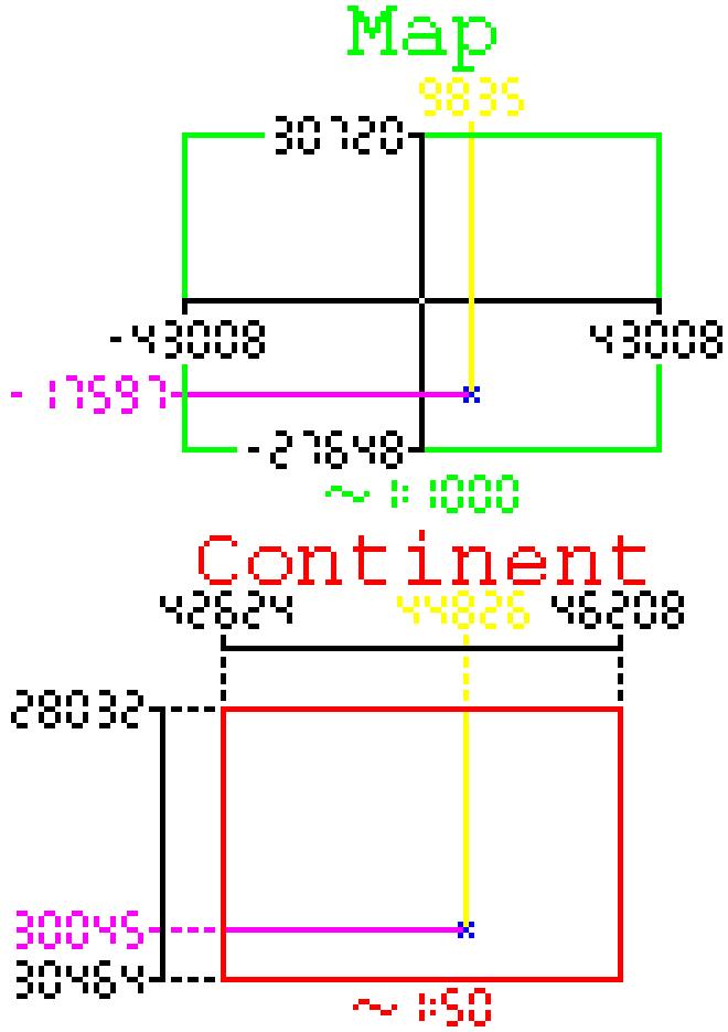
Visually depicts the relation of coordinates between the map and continent coordinate systems using the coordinates of the Defeat the shadow behemoth. event in Queensdale as example.
- Map coordinates are depicted on a scale roughly 1:1000 and continent coordinates at roughly 1:50.
- The Map rect is depicted in green and the continent rect in red.
- The two example coordinates themselfs are depicted as blue x's.
- X increases torwards the right of the image for both coordinate systems.
- Y increases torwards the top of the image for the map and towards the bottom of the image for the continent coordinate system.
- The distances between the top map/continent bound and the coordinates are depicted as solid yellow lines.
- The distances between the left map/continent bound and the coordinates are depicted as solid magenta lines.
Licensing[edit]

|
This image has been released into the public domain by its author. This applies worldwide. |
File history
Click on a date/time to view the file as it appeared at that time.
| Date/Time | Thumbnail | Dimensions | User | Comment | |
|---|---|---|---|---|---|
| current | 16:22, 2 April 2022 | | 660 × 935 (62 KB) | Medyro (talk | contribs) | Update for the new continent coordinates. |
| 05:28, 5 December 2019 |  | 880 × 795 (64 KB) | Medyro (talk | contribs) | Own work. Visually depicts the translation process from map to continent coordinates. (using the example coordinates found on API:1/event details#Coordinate recalculation) * Map coordinates are depicted on a scale roughly 1:1000 and continent coo... |
You cannot overwrite this file.
File usage
The following page uses this file: